
ES · EN
Contact us
Capturing, digitising and analysing infrastructure
A vehicle with cameras, LiDAR and GNSS drives streets and roads with the traffic and delivers a digital twin with every asset located, measured and with its condition.
Digital twin of a street built from the point cloud.
Seevia ATLAS is a platform for capturing, digitising and analysing infrastructure from a sensor-equipped vehicle.
Public space inventories are usually done on foot and soon go out of date. Seevia ATLAS gets them from a vehicle driving with the traffic.
The survey is automated from the vehicle, with less preparation time and faster mobilisation.
We mount the kit on the vehicles that already go out in your daily operation, so they inventory while doing their route.
Each drive updates the inventory and compares the condition of every asset with the previous pass.
Illustrative diagram
01
Cameras, 360 LiDAR and GNSS with IMU while the vehicle drives.
What the LiDAR sees from the moving vehicle.
02
The point cloud is classified: road, vehicles, trees, furniture.
3D inventory: the cloud classified into road, vehicles and trees.
03
Every point and asset in its position on the orthophoto.
The point cloud, georeferenced on the orthophoto.
04
A record per asset, condition and actions, linked to your GIS.
The tree inventory in the Seevia ATLAS app.
In each project we choose and mount the equipment the case needs. These are the elements we work with.
LiDAR, cameras, GNSS and IMU, chosen for each network, synchronised and calibrated.
On a vehicle driving with the traffic, yours or ours.
Georeferenced inventory for your GIS and APIs for third parties.
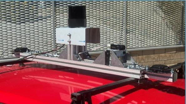
Seevia ATLAS kit on the roof rack: 360 LiDAR, RGB camera and GNSS, synchronised and calibrated.
No. It is done from a vehicle driving with normal traffic.
Yes. Tell us which asset or defect matters to you and we adapt the detection.
Yes. It is delivered georeferenced and in formats that geographic information systems import.
The surface condition and the road's readiness for automated driving (ISAD scale). The 3D model is to scale, so measurements can be taken from the office.
Tell us your case and we will look at it with your data.
Next
Seevia Waste